As of March 2026, the Australian Bureau of Meteorology (BoM) has issued multiple high-priority warnings for Tropical Cyclone Narelle. Currently forming in the Coral Sea, this system is defying conventional meteorological patterns and is being closely monitored due to its unusual behavior.
Unlike typical seasonal cyclones, Narelle is expected to become a rare “triple-landfall” system — a phenomenon where a cyclone crosses land three separate times while maintaining or regaining strength.
Why Cyclone Narelle Is Different
Narelle is intensifying rapidly and is forecast to reach severe Category 4 status. What makes this storm particularly dangerous is its longevity and ability to survive land interaction.
After its first landfall over Far North Queensland, the cyclone is expected to travel across the Cape York Peninsula. Due to the peninsula’s narrow geography and surrounding moisture-rich environment, the storm may retain significant strength instead of weakening.
Once it reaches the Gulf of Carpentaria, Narelle is expected to re-intensify over warm waters before making additional landfalls.
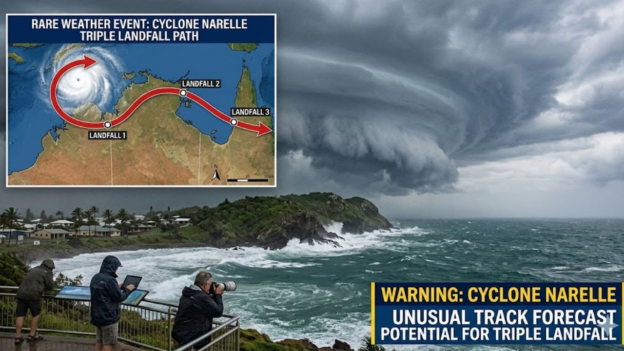
Expected Landfall Timeline
- Friday Morning: Far North Queensland (Coen/Cooktown) – Category 4
- Saturday Night: Northern Territory (Groote Eylandt/Top End) – Category 3
- Early Next Week: Western Australia (Northern Kimberley) – Tropical Low/Category 1
Immediate Risks and Safety Warnings
The threat posed by Cyclone Narelle is severe. Authorities have warned of destructive winds exceeding 160 km/h, with gusts potentially surpassing 225 km/h.
Coastal regions face the greatest risk, particularly due to storm surges and flash flooding. Already saturated river catchments increase the likelihood of dangerous flooding, even with moderate rainfall.
Evacuations have begun in vulnerable island communities, and emergency services have strictly warned against storm chasing or unnecessary travel.
Preparedness Measures
- Follow evacuation orders immediately
- Store clean drinking water and essential supplies
- Secure loose outdoor items to prevent them from becoming projectiles
- Identify the nearest cyclone-rated shelter
- Board up windows and reinforce structures where possible
Climate Factors Behind the Cyclone
While no single storm can be directly attributed to climate change, current climate conditions are contributing to stronger cyclones. Warmer-than-average sea surface temperatures in the Coral Sea and La Niña conditions are providing additional energy for storm development.
These conditions increase the likelihood of rapid intensification and prolonged cyclone activity, as seen with Narelle.
Infrastructure and Economic Impact
Direct impacts from the cyclone may lead to severe disruptions, including damage to roads, communication networks, and infrastructure in remote regions.
The Australian Reinsurance Pool Corporation (ARPC) has activated cyclone response protocols, anticipating potential large-scale property damage.
FAQs
Q1 What is a triple-landfall cyclone?
A triple-landfall cyclone occurs when a single storm system crosses land three separate times. This typically happens when a cyclone moves across a peninsula, re-enters water to regain strength, and strikes land again.
Q2 What defines a Category 4 cyclone in Australia?
A Category 4 cyclone is classified as a severe tropical cyclone, with sustained winds between 225 and 279 km/h. These storms can cause significant structural damage, including roof loss and widespread destruction.
Q3 Is Cyclone Narelle linked to climate change?
Although individual storms cannot be solely blamed on climate change, warming ocean temperatures are known to intensify cyclones, increasing their strength and impact.